Hello

Blog Search


Jul
31
0 comments
Category:

Thumbnail is a sculpture of a bull rider outside a museum in Browning which was a sorry little town and lots of examples of a community struggling. The title of the sculpture is 'An Honest Try'. There were a couple of substantial school buildings and a large modern Community Hospital with ambulances in the town but the rest of the town appears to be an exercise in despair. Very sad to see.

 IMG_1903-2.jpg

Our first shot not far out of town (and there was a similar one on the other end last night) was a sculpture and a 'Welcome' to the Blackfeet Nation. This is interesting as Norm had quite a conversation with a security guard last night who had played basketball with two Indian teams from British Columbia and Alberta (and he had played in the A Team) on a tour in Australia in the 90's and Norm had mentioned that we had thought the tribe were called 'Blackfoot' but we had seen references to 'Blackfeet' in signs through the day. He said the actual tribe names were different to those names given to them long ago by white men and in President Kennedy's days he had used that term as an inclusive term for all the Plains Indians who used to burn the ground so they could see the footprints of their enemies and they had black moccasins, and the term stuck and doesn't worry them. The name didn't mean anything to him but they had a great talk together about families and traditions and really enjoyed themselves.

 IMG_6574-2.jpg

We decided to take Highway 89 today to skirt around the edge of the mountains and retain a lasting view of them for as long as we could and for our trouble encountered 20 kms of a freshly tarred road but we maintained 30 - 33 kmh over it which kept the bikes pretty tidy. This is a shot after we got off that which appealed to Norm of a wheat field (we think) with the mountains in th distance

 IMG_1912-2.jpg

And after travelling over large areas of rolling grasslands, the grass high but not all that deeply covered and quite stony, we came to more sandy soil as well as some irrigation and again, good soil plus water means productivity.

IMG_1914-2.jpg 

And more intense agriculture again and diversification into oil (right hand side), man I'd like ne of those pumping away 24 hours a day in my back yard!

 IMG_1917-2.jpg

The sign said 74 miles to Great Falls.

 IMG_1921-2.jpg

We lunched at Choteau and after passing through a number of very marginal little communities and towns it was good to get to a more substantial place and one obviously doing better than many in the outlying areas. This is the Teton County Courthouse which was a substantial Sandstone building (quarried locally) in the process of having it's cedar shingle roofing replaced.

 IMG_1922-2.jpg

And a shot of the old silos in town. I love these old iron silos. We came across the newer version some kms from town after lunch as we headed for Great Falls in the hope of beating the thunderstorm which had developed behind us as we had our lunch.

 IMG_1923-2.jpg

And this is the 'closest' sight to a big hill in close proximity since we left this morning so after passing it I stopped and looked back to take a shot and you can see the rain gathering behind it. Incentive to get on the bikes and keep going.

 IMG_1930-2.jpg

Once we got into Great Falls we decided to visit the Lewis and Clark Interpretative Centre before we booked into our hotel as it wasn't all that far from it. In our travels along the Oregon Trail we had tripped over many mentions as it was these two (and their band) who had explored the region looking for the great 'Northwest Passage' via river from the Atlantic to the Pacific Ocean on the express orders and support of President Thomas Jefferson only to discover it didn't exist. They travelled up the Missouri River where at Great Falls they discovered a series of waterfalls and the expedition party had to drag their dugout canoes (loaded with all their supplies) out of the water and construct wheeled trolleys to transport them around the falls and it took them a month to cover the distance. When they came to the head of the river they traded with the Shoshonee Indians for horses to go through the mountains and then built more boats to travel down the Snake and Columbia Rivers to the Pacific. It was 2.5 years from when they left until their return with having to bunker down for two winters in the process and they started meeting boats coming out of St Louis as they were coming into Port. We don't have any photos from here as we took fright when we got to a window after watching a great movie about the expedition to see the thunderstorms moving in and left quickly and this is a shot of some of the falls preserved downstream of a dam wall on the Missouri River as we hightailed it to find a fuel station (as we have a big day tomorrow) and get checked in before we got very wet.

 IMG_1932-2.jpg

And this is a shot across the road from a shot we stopped for. The sign out front says 'Milwaukee Station' and I don't know if that's right or not but I liked the building.

 IMG_6581-2.jpg

This is the building across the Missouri River I stopped to take the shot of, the Missouri Courthouse and I was going to shrink it in and show more of the building but thought we would show you what we were trying to beat.

Bits and Bobs:

 IMG_1911-2.jpg

Have seen these signs for a couple of days and finally found a spot we could stop. These are the signs for cars.

 IMG_6572-2.jpg

And these for trucks on what we would call at best an Arterial Road.

 IMG_1919-2.jpg

And a shot of the roof work at the Teton County Courthouse. Norm and I would have loved all tis when we were attaching the shingles to the roof on our house in Minniedale Road, cherry picker and a saw no less!

Last Night's Accommodation:

Holiday Inn Express Hotel and Suites, 50 Museum Loop, Browning MT

Relatively new building and typical of the Holiday Inn Express Suites we have used previously nice and spacious and comfortable with all the services we need as well as pool and business centre. Included parking and wifi (very effective) and hot breakfast. No restaurant on site but next door to a Casino so cheap meals there. All part of the local Blackfoot Tribe undertaking to provide employment opportunities for their people and hopefully generate some income for the community in the long run when they are all paid for. In any case they are making a good effort here and the place was clean and well maintained and all the staff we came across throughout were cheerful and helpful and we wish them well.

IMG_1900-2.jpg


View Comments
Tags

Jul
30
0 comments
Category:

Thumbnail is a shot of Cameron Falls literally on the outskirts of Waterton which was jumping last night and today there were people heading out on horseback trail rides and group cycle rides on a tarmac track as well as heaps of hikers. It is a short time for local businesses to make their money as there is no snow field handy and they operate mid May until mid October, weather permitting, and the winter population is only 20. 

 IMG_1843-2.jpg

And farewell to Waterton Lakes, an unexpected surprise as was the opportunity to watch a small fawn and deer graze beside the deck where we ate our dinner at the Bayshore Chop House Restaurant last night.as we have had to show a number of people how to open them

 IMG_1844-2.jpg

From here we headed out briefly into the plains and as we headed for the border and the Glacier National Park we had a view of where the mountains meet the plains.

 IMG_1851-2.jpg

This is a shot of Chief Mountain with a summit of 9,080 feet and yes we crossed the border on Chief Mountain so back to feet and inches and mph. Oh and by the way these mountains aren't foothills of te Rockies but are a separate limlimestone range which has been forced upwards.

IMG_1854-2.jpg

We stopped for a coffee at the Lodge at St Mary before we turned onto the 'Going to the Sun Road' and let me tell you we were fortunate there were a lot of road works with road ripped up and gravel surface and the only pullover places full of works vehicles or inaccessible from the works or we wouldn't have gotten in yet!

 IMG_1860-2.jpg

An awesome view as we headed for West Glacier.

 IMG_1865-2.jpg

And another.

 IMG_1874-2.jpg

And yet another.

 IMG_1876-2.jpg

Everywhere we looked there were more waterfalls and as we headed down the other side from Logan Pass they were right on the edge of the road.

 IMG_1880-2.jpg

Some tourists volunteered to take our photo near the top of Logan Pass. The large peak in the middle of the shot is called 'Heavy Runner' which I assume refers to the thaw water as even now well into summer it is considerable.

 IMG_1885-2.jpg

Heading down from Logan Pass and what a dizzying view and yes that is the road cut into the hillside to the right. We have very few shots from here down as there were very small and limited spots to pullover and they were mostly full and unlike some travellers we didn't think we should stop in the middle of the road to take photographs.

 IMG_1894-2.jpg

And after lunch at the Lake McDonald Recreation Reserve this is a quick shot of Lake McDonald as the skies were closing in and we needed to make a mile or several to get in dry....which we did.

Bits and Bobs:

 IMG_1856-2.jpg

The 'Tip Jaw' at St Mary Lodge coffee shop Rather than a Tip Jar.

 IMG_1858-2.jpg

We have been moving through Grissly bear and Cougar country and this was a sign as we were heading into the Glacier National Park.


IMG_6561-2.jpg

A mountain goat enjoying the lush growth at the top of Logan Pass.

Last Night's Accommodation:

Bayshore Inn, 111 Waterton Avenue, Waterton Lakes National Park, AB T0K 2M0

Comfortable space in the bedroom but cramped with 2 beds. The building is ageng pretty well but must have a huge maintenance bill with so much timber everywhere in a brutal climate. Staff were great, good services throughout town. Included on site parking and wifi which was useless other than for email (hence no blog last night) reasonable value for money in a beautiful spot to chill out or be very active, whatever suits you. By the way the rubbish binisn't falling over. This is a bear proof bin (they are everywhere) and the top has a special bear proof latch which is apparently more effective than childproof caps on medicine bottles as we have had to show a numbet of people how to open them.

IMG_1839-2.jpg


View Comments
Tags

Jul
30
2 comments
Category:

Tyson Daniel, a son for Jessie and Aaron, Mum and Bub doing well and Great Grandparents having difficulty getting the smiles off their faces, actually they aren't even trying!


View Comments
Tags

Jul
29
0 comments
Category:

Thumbnail is a street shot of buildings and reflections of buildings near our hotel yesterday afternoon.

 IMG_1766-2.jpg

And a sample of some street art in Calgary, this one is called 'Fire'. We saw some larger more impressive pieces on the way out of town.

 IMG_1787-2.jpg

We didn't have much lined up today but a biker we spoke to some days ago suggested we head down the road to Longview as it was a great ride with big sweeping corners. Well as it turns out he was probably from really flat country with very few corners but in spite of that it was a comfortable rather than challenging ride and the scenery was just wonderful. We travelled toward Black Diamond which we assumed referred to oil since we had seen many oil donkeys operating but in the town itself there were many diagrams of black diamonds on business and municipal signs so who knows, not me. This is a shot as we started to head for Black Diamond and were delighted to see some mountaims in the distance.

 IMG_1801-2.jpg

We travelled through the foothills to the Rocky Mountains for a long time and it was wonderful with broad grassy valleys sweeping up to gently undulating hills to steeper hills and mountains beyond. The grassland was phenomenal and we literally passed through thousands of acres of country which was littered with big round hay bales. When there were cattle present (rarely) they were standing in grass almost as high as their bellies at the shortest and half way up their sides at times. The cattle groupings looked like bovine maternity wards with all cows in good condition so the hard work begins again to replenish stocks after drought. A shot looking onto Mt Sentinel Ranch.

 IMG_1808-2.jpg

Longview was aptly named with views in all directions of lush grassy plains but by this time we had seen a sign for 'Crowsnest Pass' which sounded interesting and in the direction of some great looking mountains so off we went. We found a spot in the Pass which was famous for a disaster in the town of Frank in 1903. A limestone wedge 425m long by 150m deep broke free from the top of Turtle Mountain and smashed apart as it slid down the mountain literally covering the valley floor and obliterating part of the town. 70 people died but not the men working underground in the coal mine, they tunelled out. Just to get road and raiI line back in has been quite the engineering feat.

 IMG_1804-2.jpg

The Pass was spectacularly rugged and beautiful and they even have a golf course and country club.

 IMG_1811-2.jpg

A waterfall down river from the site of the disaster with the same train.

IMG_6513-2.jpg 

We headed back down the pass to find 'Head Smashed in Buffalo Jump' among incredibly lush and flat to undulating grassland which we expected to be the highlight of the day and it probably was. This was a cliff area where since some 6,000 years go until around 150 years ago when they gained access to horses and guns the Blackfoot Indians used to herd the Bison over the edge of the cliff to kill them and they would then set about preserving the meat and fat for sustenance then and future use and using the hides for clothing and tents and bones as tools and weapons. The interpretative centre was impressive. It was 7 storeys from the ground floor to the top where we walked along the cliff top and it was situated quite a distance above the valley floor so the fall was considerable. The centre handled the history and context of it well with the Indians livelihood as well as the demise of the bison once European man came on the scene. Embarrassing really.

 IMG_1814-2.jpg

On the cliff top.

 IMG_1834-2.jpg

It was getting late in the day as we headed for Waterton National Park and there were several areas of rain in all directions which we had avoided throughout the day but it looked like we would get dumped on before we got in, thankfully we didn't but we got some great shots of threatening skies. We expected a ride in flat featureless country but nothing could be further from the truth. Initially we had more undulating grassland with many warnings of high wind gusts and not surprisingly prolific numbers of wind turbines but we turned toward some more hills which led to mountains and yet again WOW!. A view from Pine Ridge viewpoint as we are heading into the Natiomal Park.

 IMG_1837-2.jpg

The Prince of Wales Hotel where we are not staying but literally sitting on top of a rocky outcrop above the lake.

 IMG_6522-2.jpg

And a shot of the lake. Just beautiful.

Bits and Bobs:

 IMG_6496-2.jpg

Finally got a decent shot of an oil donkey near Longview.

 IMG_6497-2.jpg

Just out of Longview a reminder that we were in remote territory.

Last Night's Accommodation:

International Hotel Suites Calgary. 220 4th Avenue Southwest, Calgary AB

Generous comfortable space in the bedroom and sitting / kitchen space....the smallest space was the bathroom which was even smaller than a majority we have had so far, go figure! Included wifi and breakfast. Bar, lounge and cafe on site and a nice dinner in a comfortable chair was good at the end of the day. Between when we booked and today the parking has gone from off-site to within the building with a lift to rooms so worked well for us.

IMG_6481-2.jpg


View Comments
Tags

Jul
28
0 comments
Category:

The thumbnail is a shot of the bikes in front of Minnewanka Lake. Really pretty. This is a dam which has had it's capacity increased by 14 feet in the early 90's then another 65 feet in the 1970's as water was directed from Johnson Lake via a large canal we ultimately rode past.

 IMG_1750-2.jpg

And another view of Minnewanka as we rode the Loop Road further around the mountain.

 IMG_1752-2.jpg

From here we headed back toward Banff as we had seen a sign to Tunnel Mountain which had intrigued us so we set off to find it and find it we did. Turns out at the time of the original Railway Survey of the area in the 1800's the mountain to the right of the shot was deemed to be a hindrance to the line and it was decided a tunnel was needed. At th end of the day an alternative route around the mountain was built but the mountain retained the name. Doh! Picturesque ride anyway.

 IMG_6466-2.jpg

We headed off on the Trans Canada Highway and at the first opportunity diverted off onto 1A which was a great ride though when it was the main highway it would have been an incredibly frustrating drive I would think with limited spots to pass or pullover. We called into the little town of Canmore for a coffee and talking to the locals who realised we were Australians referred to us having 3 mountains called the 3 Sisters and then directed us to see their 3 Sisters and here they are, from left to right, Frances, Olive and Grace. I don't know if our own 3 Sisters in the Katoomba Mountains are individually named or not. Does anyone else know?

 IMG_1760-2.jpg

Then cruising along the road we spotted a great mirror image of Nakoda Lodge in a lake and decided to see if we could get a shot. We didn't get the Lodge from the angle we could reach but I was happy with this shot looking back to the Canadian Rocky Mountains which were beginning to shrink behind us at this point.

IMG_6477-2.jpg 

We gradually saw the great Canadian Rocky Mountains disappearing into the distance and as I'd stopped for another photo shot Norm thought it was a good chance to record a farewell shot.

 IMG_6479-2.jpg

As we progressed toward Calgary the mountains continued to shrink behind us and the river dropped into a deep valley and the hills were covered in fewer trees and flowing grasslands. As we approached Ghost River Dam we must have been in Reservation Territory as we saw a sign to 'Chief Stoneys Rodeo' and went past a massive building obviously an indoor one. A bit later on we spotted a sign to Stoneys Medicine Hut but this is what caught Norm's eye, the remains of a massive old barn.

 IMG_1764-2.jpg

We fuelled up in a Reservation compound site attached to what looked like a massive Gas Fraccing operation with temporary accommodation back on the highway. The reservation has gained a nice new Youth Centre and very smart Servo complex and what looked like a big Casino. Hope it ends up a long term plus for them. Just beyond here we came across the Ghost River Dam (above) and soon after we were within site of rapidly developing outer suburbs and then Calgary where friends Frances and Trevor have attended the Calgary Stampede (Frances many times). We rode past a huge centre where some of it at least takes place.

IMG_1767-2.jpg 

The Chinese Cultural Centre, Calgary.

 IMG_6487-2.jpg

And a view across James Park to two very different towers of two very different times.

Bits and Bobs:

 IMG_1756-2.jpg

After missing a great 3 in 1 sign of a Caribou Bear and ? Not sure what, I wasn't going to miss this one where there was room to pull up. Didn't see any on the ride.

 IMG_1770-2.jpg

And this is typical of grates on the footpaths in Calgary so a handy reminder to keep right.

 IMG_1785-2.jpg

And a nifty way to accept deliveries in multi-storey buildings. Drive in and onto the turntable which then turns to the right spot and then you can reverse to the appropriate unloading dock. Handy for cities with limited space but also caters well for their brutal winters.

Last 2 Night's Accommodation:

Banff Caribou Lodge and Spa Banff, 521 Banff Avenue, Banff AB T1L 1H8

A lovely place to drop for a couple of days. Lovely welcoming atmosphere and staff. Great facilities. Comfortable room and bed. Beautiful swimming pool and spa complex on site. Included underground parking and wifi. Great bar and restaurant on site and the service throughout has been excellent. Considering the proximity to town and a lot more expensive options thought this was good value.

IMG_1680-2.jpg


View Comments
Tags

Jul
27
2 comments
Category:

Thumbnail is a shot of the back side of the Fairmont Banff Springs Chateau because the sun wasn't shining on the front, but it was all impressive. 

IMG_1685-2.jpg 

We fuelled up first thing on our way to the bottom of Sulphur Mountain for a Gondola ride and kept tripping over the 'Free Banff Parade' with all the cadets from surrounding districts marching. Not sure what they were freed from or when but they looked impresive.

IMG_1691-2.jpg 

On our way to the Gondola we spotted some people out for a serious ride by the look of the supplies they carried. This is an old camping tradition throughout the Rockies. Nice.

IMG_6450-2.jpg 

Parking was at a premium again with cars parked in precarious positions a big distance from the gondola departure site. We found this camper parked in the middle of 2 spots so decided to help ourselves to the leftover space.

IMG_1721-2.jpg 

The Gondola ride was awesome and there was a huge climb up and down stairs once we got to the top to observe more mountains around an observation site. Beautiful and a bit much to take in really. This is overlooking Banff and surrounding country and mountains. Awesome.

 IMG_1712-4.jpg

And this is in the other direction from which we came yesterday. You can see the Trans Canada Highway which we didn't take and to the right of that is the 1A route we did. We checked out some of the highway today and it does give a 'BIG' view of everything around.

 IMG_1713-3-2.jpg

And this is a work shot of a train we estimate approximately 2 - 2.5 km long snaking it's way through the valley and the reason they are vaguely visible is because they are double decker containers. Awesome.

 IMG_1707-2.jpg

And a shot of the Fairmont Banff Springs from the summit.

 IMG_1728-2.jpg

We headed back to the hotel to ditch the merino long johns so we didn't expire then grabbed some lunch in Banff before we headed off again and this is a shot in Banff Avenue the main drag and it was hopping today. Also very pretty and no end of shops open if that is what interests you.

 IMG_1677-2.jpg

And a shot of Castle Mountain which we also spotted yesterday. We came back past here today to check out the Johnston Canyon and again we were grateful we were on the bikes and could squeeze into a tiny spot in the carpark instead of having to park hundreds of metres away on the road. Incredible.

IMG_1738-2.jpg 

We headed up to check out the Lower and Upper Falls in the Canyon with what seemed hundreds of other frustrating people who didn't understand about single file walking or blocking a thoroughfare or expecting the world to stop so they could take a photo. I waited and was patient on the way up but on the way back I was totally snookered and heading for an ice-cream and I wasn't stopping for anyone or anything. This is a shot of the Lower Falls.

 IMG_1746-2.jpg

And this is a shot of the Upper Falls! Are you joking? I climbed up and down for 2.6 km and I mean up and down on the way to and from and this is all I get????


View Comments
Tags

Jul
26
0 comments
Category:

Thumbnail is a shot of a duck on Emerald Lake and the water is both incredibly clear and translucent, we could even see him paddling...I wonder if that means he can get a better view of his potential dinner!

 IMG_6425-2.jpg

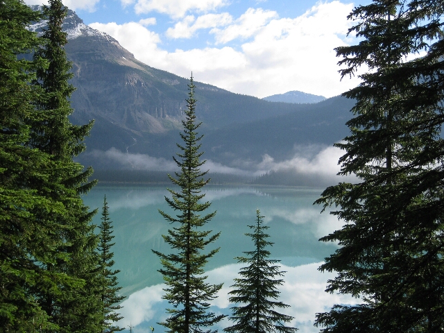
A shot of Emerald Lake this morning before we left with the sun coming out after the fog lifted.

 IMG_1620-2.jpg

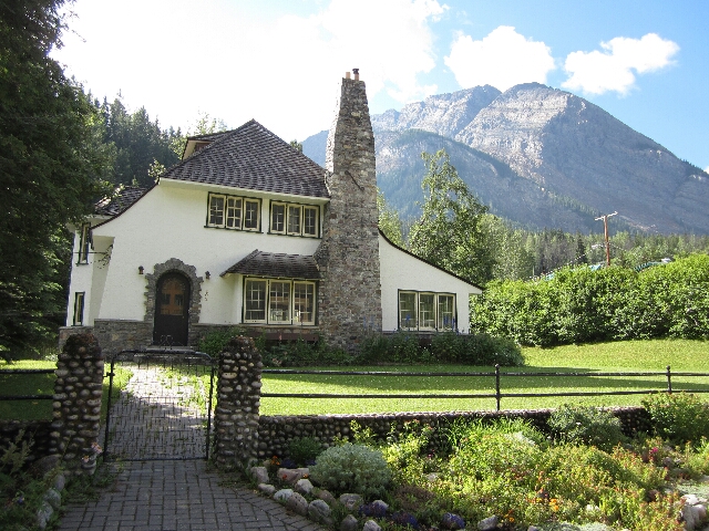
We headed into Field, a tiny little Village and this was one of only 2 substantial building's we saw. One looked like it used to be a railway station (tiny) but covered in dense shade. This one was the home of the Park Superintendent built in the 1920's at a time when both the Railway's and Mining were huge in the area and the town being in the Yoho National Park the National Parks Service realised they needed to build a building which spoke of the authority of the Superintendent as well as recognising such building's were starting to have heritage value. I liked it and it still looked great.

 IMG_1615-2.jpg

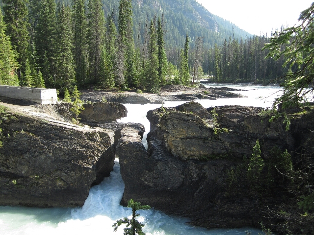
We called in to have a look at a 'Natural Bridge' which used to be a waterfall until the water wore it's way through and before too many hundred years I guess it will no longer be a natural bridge as it also collapses. A huge volume of water was pouring under it.

 IMG_1628-2.jpg

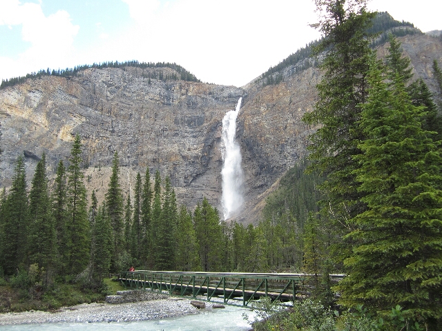
From here we headed off to see the Takakkaw Falls and they were just spectacular. The water plummeted down from the Lake above and then burst out in a plume of spray before falling into the river below. Awesome. 

We took a couple of photos of a train travelling through the Spiral Tunnels on the way back from here but with the sun where it was the exposure was awful so not here. Incredible example of engineering.

 IMG_1636-2.jpg

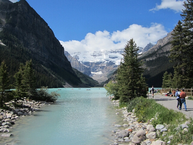
And then on to Lake Louise with half of Canada and the rest of the world. Saturday, fine weather, summer holidays etc etc etc, Cars were illegally parked on the side of the road for a 2km distance before the Lake. Today was definitely a good day to be on the bikes. We managed to squeeze into a small spot at the end of a parking lot. This is a shot of either one of or the outlet from the lake. What a beautiful spot and full of people in small boats.

 IMG_1639-2.jpg

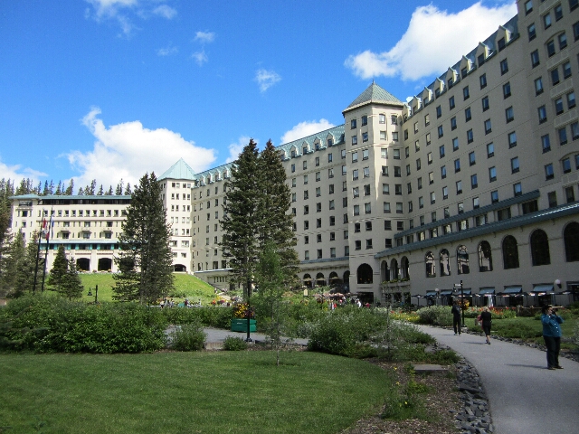
And the Chateau Fairmont which I automatically think of when I think of Lake Louise. We are used to the view from above (obviously from the Lake Louise Scenic Gondola which we didn't go on) this was close enough for us. We lunched on the patio of the Chateau Saloon under the umbrellas at the centre of the hotel. Very nice

 IMG_1650-2.jpg

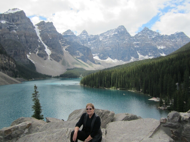
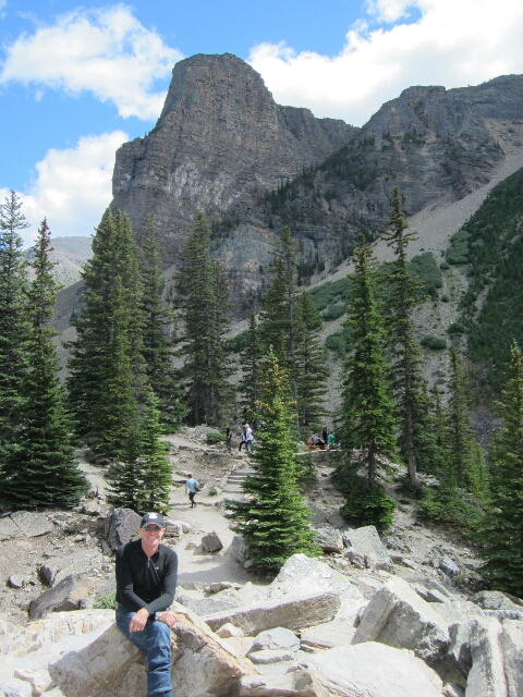
From here it was on to Moraine lake and yet again, WOW! This is a shot of me with some of the peaks from the Valley of 10 Peaks behind me.

 IMG_1651-2.jpg

And this is Norm in front of a rugged outcrop named the Tower of Babylon.

 IMG_6448-2.jpg

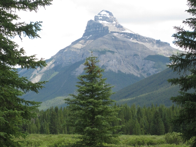
And compliments of a tip from another biker who parked beside us at both Lake Louise and Moraine Lake we travelled to Banff via 1A rather than the Trans Canada Highway which was a beautiful ride with spectacular views of mountains of all shapes, sizes, colours and stature and this is one of them.

Bits and Bobs:

 IMG_1630-2.jpg

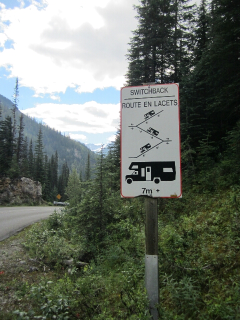
Interesting sign for a switch-back on the way to the Takakkaw Falls. Vehicles over 7m must drive the first section, then reverse the next then drive the last. VERY tight.

 IMG_6430-2.jpg

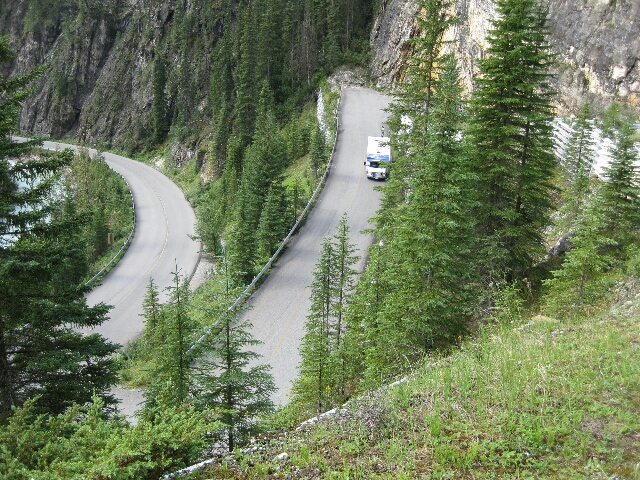
And a shot from above.

 IMG_6444-2.jpg

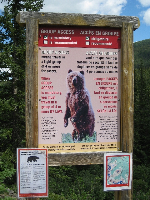
A sign we found on the path to Consolation Lake as we climbed for a view of Moraine Lake. Decided not to be bear food and stayed on the track we were on.

 IMG_1668-2.jpg

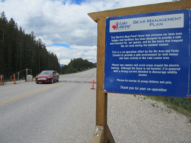
And another sign re bears at the entry to the Lake Louise Scenic Gondola site and Whipstick Lodge.

 IMG_6443-2.jpg

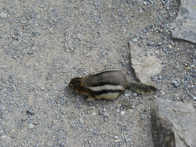
And finally a chipmunk shot. Yay!

Last Night's Accommodation:

Emerald Lake Lodge, 1 Emerald Lake Road, Field. BC

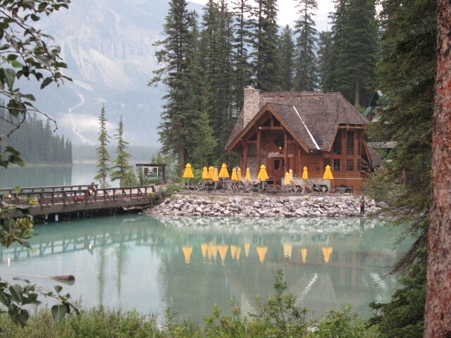
Not sure what happened here but the most expensive night we have had and not necessarily good value for money. Not sure if I ticked the wrong choice or there were limited options cannot remember, but that aside we had a lovely upstairs room with easy chairs and open fire in a cabin overlooking Emerald Lake. Cosy and comfortable, good bathroom, small balcony with deck chairs. Included parking 1km away (at employee residences) with shuttle which was a bit of a pain with the bikes waiting until cold enough to cover and to get kitted up to head off. Included wifi TV and games room in main Lodge. 3 restaurants on site and canoes and row boats for hire. If we removed the views and setting and kept the fireplace you may well think it was reasonable value at half the price.....perhaps. Not convinced. This is  a shot across the bridge entry and of one of the restaurants 'Cilantro on the Lake.'

IMG_1609-2.jpg

To quote Norm, "Note to self, Lodges sound romantic but remember they're usually old and rustic with small rooms, stairs, limited services and facilities and a large charge, but generally come with good views".


View Comments
Tags

Jul
25
0 comments
Category:

Thumbnail is a shot shortly after we set out this morning and yes there was more snow overnight on the peaks and the day today was grey and misty and cold but we were nice and comfortable. God bless grip heaters, merino long johns, padded oil skin pants and the usual bike clobber. 

 IMG_1533-2.jpg

I passed up a shot of a family of deer / caribou / ? laying down but this was too good to pass up. If I hadn't diligently thrown unnecessary paper in the bin last night I could have identified them.

Not surprisingly Norm got a bit ahead of me while I took the previous shot and I was a couple of cars behind him when I noticed his stop light come on and then something black bound over the guard rail and when I checked with him at the next stop I discovered he had experienced a close encounter of the bear kind, a black bear to be precise. While I assumed he was slowing down he was in fact in the process of an emergency stop as a big black bear had climbed over the guardrail and toppled a bit as it went over and as it landed in the road in front of Norm they both had time to look at each other and register an 'oh shit' moment and Norm figuring at best even with an emergency stop he would just hit the bear which would likely upset him a bit he applied the brakes and was delighted how well the bike performed, as for the bear he spun around and bounded back over the rail into the forest. Phew, good outcome for all concerned. No thought of taking any photos there!

IMG_1539-2.jpg 

The Athabasca Falls. What an awesome demonstration of how the force of incredible amounts of water plus sand particles can carve through limestone rock like a diamond drill. Wow, loved it. 

 IMG_1543-2.jpg

And soon after, Sunwapta Falls, yet another example of the same process.

 IMG_1550-2.jpg

And a shot as we were heading for the Columbia Ice field.

 IMG_1562-2.jpgl

And this is the Athabasca Glacier. Where I took the photo from was where the glacier extended to in 1844 so it has retreated bit. The peak to the left is called Snowdome and has a summit of 3,456m and the one to the right is Andromeda with a summit of 3,450m.

 IMG_6395-2.jpg

Shortly after the last spot the GPS said we were crossing Rousseau Creek but I guess with compliments of the snow this is what we found.

IMG_1588-2.jpg 

And Crowfoot Glacier shortly after.

 IMG_6402-2.jpg

We lunched and fuelled up at the Saskatchewan River Crossing.

 IMG_1576-2.jpg

We passed through incredible rocky canyons like moving from one cathedral to another intercepted by rocks pushing upwards like great long plinths reminicent of stonhenge, gothic cathedrals and fort battlements. One of the outcrops.

 IMG_1584-2.jpg

We headed to Bow Summit and would probably have been looking across at it from the view point but it was covered in cloud. This is a shot across Bow Lake. There was also a sign to Observation Peak which was 10,214m, needless to say we didn't see this one either.


IMG_1589-2.jpg 

And a shot of the disintegration of the hillside beside the crowfoot glacier. We have ridden through many avalanche areas where not only snow sweeps down but also the rock underneath and this is an example of what happens as the ice expands under stone then melts and washes down the hillside. Many dramatic examples today.

 IMG_1600-2.jpg

And lastly the view onto Emerald Lake from our room tonight.

Last two Night's Accommodation:

Chateau Jasper, 96 Geikie Street, Jasper, AB, T0E 1E0

Good sized room and bathroom combo. Plenty of wardrobes/ Free wifi and parking. On-site gym, pool, hot tub and restaurant where we celebrated Danny's 44th birthday to the lovely sounds of piano music which somehow seemed fitting given that Tania is a pianist. Older building than some but maintained well. Reasonable value. Easy walking distance to where there is more activity in the town if that's what you want. Staff very helpful and friendly, laundry available in neighbouring building so all our laundry sorted for $4.00 so heaps better than hand washing in the room and every available surface being used as hanging space. (So far we have only had 1 room with a clothes line and that was a night I didn't wash).

IMG_6375-2.jpg


View Comments
Tags

Jul
24
0 comments
Category:

The thumbnail is a view from the restaurant where we had breakfast this morning after the rain had actually stopped. 

We did our laundry when we got in yesterday arvo because we had a big tourist day lined up today but the day dawned wet....very wet and the mountains around us fogged in and that's how it's supposed to be for the next 2 days. Bugger! We wandered into a gift store after breakfast and bought a video so we can get to see what is here when we go home. How sad is that? If we had been given the choice we not surprisingly would have ridden through a couple of days of sleeting rain through the featureless plains we have encountered earlier in our ride.

After a bit Norm made a big statement 'Well look at that it's as good as sunny outside, let's get on the bikes and see what we can see'. What that meant was that from our 2nd storey window the rain drops were now small enough for him not be able to see them splash in the puddles on the ground, so what the hell, we kitted up and headed off and had a great day.

What we were supposed to see:

1. The Jasper Tramway (gondola / cable car) the longest and highest in Canada to the top where we would have had an awesome view back down to Jasper and across to all the other surrounding peaks but while there was rain in Jasper last night there was snow on the peaks surrounding us and most of that covered in cloud so we figured that was a waste of time.

 IMG_6377-2.jpg

2. Athabasca River to Maligne Canyon, a narrow limestone gorge with an opportunity to traverse 2 bridges over the canyon with great views to the water and falls below. Done and the shot above is a shot on our way out of town as we headed for Maligne Lake.

 IMG_1494-2.jpg

 IMG_1509-2.jpg

IMG_1523-2.jpg

3. And these are shots of the Maligne Canyon above from well down stream to up stream closer to Maligne Lake.

IMG_1515-2.jpg 

4. Multiple views including the Colin and Queen Elizabeth Ranges and Medicine Lake. Done and the shot above is looking toward the Colin Range. Almost a vertical cliff with many avalanche areas and some stubborn trees that just wont give up.

IMG_1532-2.jpg 

And this is a shot of Medicine Lake which drains undergound so rarely flows over so the watercourse downstream of the Lake can be dry for a year or more and literally has large tees growing in it.  

 IMG_1520-2.jpg

5. A guided tour of Maligne Lake with views of magnificent shoreline with dense forest and glacial peaks. No guided tour but enjoyed the ride and the view when we got there and overall it would appear that the weather we experienced through the day was less wet than what Jasper experienced, Yay.

 IMG_1526-2.jpg

And a shot on our way back from the Lake.

IMG_6385-2.jpg 

And a bonus shot for Norm......a bit of an adrenaline rush as well. He decided he would try for a quick shot and if the Mum looked his way he would get the hell out of there. He thought he had another shot as well with the little baby close to the road with its Mum. Damn thick bike gloves apparently stymied that attempt so I'm glad he got this one.

Bits and Bobs:

IMG_6381-2.jpg 

One of many signs on our trek, and a great view behind as well. We didn't see any.


View Comments
Tags

Jul
23
0 comments
Category:

Thumbnail is soon after we headed out this morning to grey cloudy skies and light rain, and while we are talking weather, the moon didn't dance on the bay last night it was stuck behind clouds. The weather thankfully cleared and even though there was to be heavy rain behind us we stayed dry and for the most part rode under clear skies and some sun as well so comfortable.

 IMG_1465-2.jpg

We fuelled up at Little Fort and this was the quirky barn across from the fuel station. The sign said 'Little Fort Herefords'.

 IMG_1467-2.jpg

The sights we saw again today were awe inspiring and hard to limit here. This was a shot of water typically galloping down from glacial mountains (hence the cloudy colour). So many better shots, but this one I could get.

 IMG_1478-2.jpg

Mount Robson, the highest peak in the Rockies according to the gentleman we talked to at this rest stop taking a coffee break in his 5th wheeler. He had been part of the construction crew which built the original road 47 years ago, up until that time there was only a trail which was often impassable. The rail line was already through. He told us there is a rest stop closer to Jasper (a few kilometers further) and the construction camp they lived in was on the opposite side of the road and if they walked east along a track they reached the Fraser River and the rail line. He said they would come by train from Jasper at the start of the week to the camp and then flag the train down on Saturday to go back to Jasper to drink beer. Sounds about right. The crew from the other end caught the train from Blue River in until both ends finally met up. Must have been an awesome project and to think we see this as remote now, how much more so must it have been then!

 IMG_1481-2.jpg

Norm after the perfect shot of yet more snow covered mountains. We also saw some awesome freight trains. By the way, the white spots are some sort of seeds in silky groups of thread floating in the air, we were surrounded by them in a number of places today.

 IMG_6366-2.jpg

Mount Fitzwilliam. Just beyond here we came across a lot of marsy reed surrounded water again and Norm hoped we might yet see some moose attending their daily ablutions and splashing a bit of water up to the arm / leg pits but to no avail. This would be a preferable place to find them rather than on the road.

 IMG_1485-2.jpg

The Jasper National Park Entrance and I had to put this one in because it has an eagle right in the centre.

Bits and Bobs:

 IMG_6343-2.jpg

A tuck at Little Fort this morning. These are concrete railway sleepers but different to the ones we sometimes carry as they are in groups. Check out the truck / trailer configuration.

 IMG_6345-2.jpg

Yes our lunchtime diner had a phone at the table. This was a 'Husky' Diner and we read that they had started here at Blue River which started as a logging camp and has developed into a snowmobile hot spots as well as helicopter skiing and just about any other scary thing you can do on snow which appeals to adrenaline junkies. This is the ideal spot (further up the , mountain I suspect) as they have a 40 foot snowfall each year.....and yes I did say 40 foot. Not all at the same time obviously but makes for great powder sports....or so the blurb stated.

 IMG_6363-2.jpg

We saw bear warning signs all over the place today. This is at the start of a trail at the foot of Mount Robson.

Last Night's Accommodation:

Moondance Bay Resort, 7237 Johnstone Road, Bridge Lake. BC, VOK 1X2

A good spot for people who want to retreat from the world with no TV, internet or wifi and the only food options those you bring in yourself, source from local general stores or you catch yourself in the lake. Comfortable cabin and bathroom, comfortable space overall with 2 couches and a self contained kitchenette. Deck chairs and table to relax on the veranda and picnic table and fire pit as well. Guest B-B-Q available as well as a fish shed for cleaning the catch and good children's playground as well as boats to hire. Nice spot for families and lots of caravan and RV sites as well. Good value and an interesting change for us rounding up dinner choices with limited space on the bikes.

IMG_1463-2.jpg


View Comments
Tags

Jul
22
0 comments
Category:

The thumbnail is our first shot of the day, a fuel stop at Pemberton after going to 2 non-existent fuel stations in Whistler and surrounds, the planners are obviously moving such distasteful things away from the population. Already seeing great snow capped peaks and the sights just kept rolling out from there. Snow capped mountains, rugged rocky canyons and sheer mountainsides, desert like canyons and ranch land as well as dense forest from sparse and dry to dense and lush green and water water water. Cascading down mountainsides and galloping along creeks and rivers into lakes of all description. We also saw lots of high country boggy marshland with small and large lake areas before we got in this evening. And the roads! They were just spectacular, the surface was excellent to good and when not excellent just a bit bumpy and corner after corner after corner all with steep cambers for draining snow and sooo good for bikes, not to put too fine a point on it, a bit over 300kms of bliss! Aaahhhh. But, now to some of many shots of the day.

 IMG_1420-2.jpg

Yep, more great snow to be seen in the distance so a comfortable temperature to travel.

 IMG_1423-2.jpg

And Lakes, one of many, we chatted with a couple from Arizona having coffee in their camper here.

 IMG_1430-2.jpg

And they aren't called the Rocky Mountain's for nothing and this is a pathetic example compared to what we have seen but it is a case of so many shots (so few places to safely stop) and lots of kilometers to cover so limited time and a strict timekeeper in Normie John.

 IMG_6335-2.jpg

Just before our lunch stop in Lillooet traffic was stopped while 3 helicopters worked as a team to lay cable for the hydro plant. Very impressive. Norm shot this one....well with the camera.

 IMG_6332-2.jpg

And this is a shot of either Lilloolet Lake or Seton Dam (not sure which but assume dam as they have had submarines diving to do surveys) and check out the train line which winds it's way along the shore to the right hand side. Mainly freight these days but there is a one carriage passenger train used for leisure things but which also brings children to school in Lilloolet. There used to be a 3 hour trip around the mountains and they boarded in town from Sunday night until Friday afternoon but now they commute each day. Also, around the corner heading up the dam is a corner called Dead Mans Corner after a train derailed and plunged to the bottom. Apparently the owners got a whole lot of experts in who said it couldn't be raised as it was too deep but some farmers and loggers sank heaps of 44 gallon drums then pumped the water out and replaced it with air and raised the engine. Ha ha, love what is possible when practical people get a chance to do things. Also handy to talk to locals as you might have guessed and we get to do that a lot on the bikes.

 IMG_1437-2.jpg

This is a shot looking downstream from the dam and you can see salmon spawning pools which have been built to help the salmon get upstream to spawn.

 IMG_1438-2.jpg

This is a little bit of the canyon wall in an area called Marble Canyon. There was a massive quarry just past here. Don't know that it was marble but the colour in the white stone looked very impressive.

 IMG_6339-2.jpg

A shot of the General Store, restaurant, gift shop and admission gate at Hat Creek Ranch.There were camp sites, spots for RV's and caravans, play sites for kids, a circular sale yard and opportunities to do 'real ranch things'.

 IMG_1459-2.jpg

A shot from the Moondance Bay Resort across Bridge Lake and this is the pontoon the owners were rescuing when we arrived as it had come adrift......going on the very un-truckie knots on the rope now on it the same thing could happen again.

 IMG_1453-2.jpg

And finally, the view from our cabin. The fire pit would be fun except there are no fires allowed in the open at the moment as the fire risk is extreme. There is a fire currently burning to the east of the ranges in Washington State (USA) south of here which is the worst in history with 1 life lost and over 150 homes. We have been keeping a close eye on this in our travels but thankfully smoke has been our only issue.

Bits and Bobs:

 IMG_1439-2.jpg

We stopped for a break and an ice-cream (delicious) at the Hat Creek Ranch and this was a great photo on the veranda of an olden day version of a road train at the Ranch in years gone by. En route to Barkerville. Awesome.

 IMG_1445-2.jpg

And continuing with awesome, there was a bird feeder on the veranda and it might only be a silhouette shot but I got my shot of a hummingbird. Yay. Still have to work on the squirrels though got one last year so forget that, but they are slow compared to the chipmunks we encountered on the Needles Highway in Yellowstone. We will see.

Last Night's Accommodation:

Crystal Lodge, 4154 Village Green, Whistler BC VON 1B4

A nice room but small. Lots of wardrobe space for bulky snow items and shelves but struggling for space to open out 2 suitcase's. No matter, we weren't in the room for long. The Village had a great atmosphere and it is right in the heart of it so ideal location. On site gym and pool and discounts available at lots of shops on site. Parking available at a reasonable cost but not locked up so glad we had our disc brake locks. Staff great and there were more expensive options re rooms but we didn't want them. On site restaurant but with a steak worth $39.00 we figured we would eat out and we were literally a few metres from heaps of eating choices. Found a great pub with excellent restaurant meals. Spoilt for choice. Reasonable value.

IMG_1413-2.jpg


View Comments
Tags

Jul
21
0 comments
Category:

No mention of wifi / internet of any description tomorrow night so likely won't hear from us until the 23rd.


View Comments
Tags

Jul
21
0 comments
Category:

The thumbnail is a shot of the bridge we left Vancouver on as we headed north for Whistler.

IMG_1340-2.jpg

We have had a spectacular day and loved every minute of the ride. The views from ocean to mountain and everywhere in between have been just awesome. We've also loved the fragrance of cedar timber in the villages especially where ther has been new construction underway, it's reminded us both of our cedar house in Minniedale Road. This was the first shot for the day soon after we started to climb up from the ocean into lush forest.

 IMG_1348-2.jpg

And this is a view as we were well and truly above the ocean.

 IMG_6306-2.jpg

We had a coffee at Squamish and this is a shot at the waterfront. You can see plenty of logs which have washed up from where logs are loaded on ships further around the waterfront from here.

 IMG_1350-2.jpg

Lunch stop was at the Creekside Village and this is a typically pretty building we saw here and beyond, in fact the value of real estate we have seen has been staggering!

 IMG_1356-2.jpg

A shot as we headed up the Whistler Village Gondola. We couldn't get over the number of mountain bikes and riders who also caught all the gondolas and chairlifts we did today and then hurtled down the mountain!

IMG_1368-2.jpg 

And a shot from the chairlift to the Whistler summit.

 IMG_1370-2.jpg

The Summit, starting to be overtaken by cloud.

 IMG_1372-2.jpg

And a view back to where we had come from and this shot has been shrunken in.

 IMG_1383-2.jpg

The cloud coming in as we headed across on the Peak 2 Peak Gondola from Whistler to Rendezvous Lodge with the intention to head up the 7th Heaven Express Chair Lift but the cloud beat us so we headed back down from the lodge, and let me tell you we were definitely wearing the right gear for the temperature since we still had our bike gear on.

 IMG_1388-2.jpg

Also from the Gondola, when we were over the river we were quarter of a mile above it.

 IMG_1408-2.jpg

The square in Whistler where the original Gondola left from.

 IMG_1412-2.jpg

A view along the street in the village and the foot traffic increased as the evening went on.

Bits and Bobs:

 IMG_6300-2.jpg

Headed back to the 'Back Forty' for dinner last night and this is the seating sign. Means just grab a spot where it suits and they'll find you.

 IMG_6301-2.jpg

And the reverse of the sign we showed you the other day. I think we have all worked at some time with people who have this problem.

 IMG_1353-2.jpg

And we missed a great sign today because we couldn't stop which had a picture of a bear and said "Caution bears next 60km, do not feed bears" but this one we did get a shot of as we lined up for the gondola ride up Mt Whistler.

Last two Night's Accommodation:

Hampton Inn and Suites by Hilton Downtown Vancouver, 111 Robson Street, Vancouver BC V6B 2AB

Comfortable room and amenities. On site bar restaurant and parking. Included wifi and breakfast. Ideal spot if you want to attend a game at the BC stadium literally across the street and walking distance to lots of other great spots.

IMG_1334-2.jpg


View Comments
Tags

Jul
20
0 comments
Category:

IMG_1229-2.jpg 

Slept in late then after breakfast we headed off to find the 'Hop On Hop Off' trolley tour of Vancouver and got a trolley driver who didn't know the city and could barely speak English so we hopped off really quickly at the first available stop and had a coffee in the Pacific Centre before we hopped back on again. This is shot from our coffee spot. From here on we discovered that Vancouver is also a beautiful leafy city and very livable with apartments and community gathering places scattered about all over town.

IMG_1254-2.jpg 

Spotted this roof and figured it had to belong to the Fairmont Family and yes it is the Fairmont Vancouver.

 IMG_1241-2.jpg

A busy Container Port was also part of what we saw.

 IMG_1267-2.jpg

A view to the city from Stanley Park which was a beautiful spot with magnificent trees including some massive old growth trees, rose garden and yacht clubs. Very picturesque.

 IMG_6285-2.jpg

An example of an old giant still surviving.

 IMG_1325-2.jpg

The entry to China town, the second largest outside China apparently with the first being in San Francisco, at least according to our driver.

 IMG_1329-2.jpg

A nice spot on our tour and the site of an early saloon in the town. We decided we might walk back to here for lunch as there were lots of eating spots and people but then the skies opened up so we headed across the street instead.

Bits and Bobs:

 IMG_1330-2.jpg

Some quirky stools in the 'Back Forty' across the road from our hotel.


View Comments
Tags

Jul
19
0 comments
Category:

We had a ferry to catch this morning so decided against our breakfast choice of yesterday morning and as we headed for the car park we were glad we had. The thumbnail shows that not only were people lining up inside but outside as well.

 IMG_1214-2.jpg

We had a spectacular ferry ride from Schwartz Bay Ferry terminal to Vancouver City on British Columbia Line. A very smick operation, very organised with minimal turnaround times. Impressive. Too many shots of water and tree covered islands to even begin. I was glad to see we had emergency back up if it all turned pear shaped.

 IMG_6271-2.jpg

Same company boat heading back to where we had come from. We had just negotiated the narrow passage they are heading for.

 IMG_1220-2.jpg

The blurb on our accommodation said 'in the Stadium district' and this is the Stadium across the street from our Inn. We were blown away by the volume of music before the game of football began but it's a great atmosphere in the community.

 IMG_1224-2.jpg

Just up the hill from our Inn is this Library (the round building).

 IMG_1227-2.jpg

And the open space beside it is undercover from the surrounding wall across the open space. A reminder of the ferocious cold / wet / snowy weather encountered here.

Bits and Bobs:

 IMG_6275-2.jpg

Hope there was nobody in here when this got blown / knocked over.

 IMG_1221-2.jpg

Norm spotted this out the front of a pub type restaurant.

 IMG_1222-2.jpg

And this is a serious mobile B-B-Q at the same place. Wood fired.

Last two Night's Accommodation:

Hotel Rialto, 653 Pandora Way, Victoria BC V8W 1N8

Happy to report we have had a nice stay for Norm's birthday in Victoria. The Hotel was lovely. Generous space in the room and bathroom (junior king suite) comfortable bed, nicely furnished,  shower, as in real shower not over a bath. Yummy restaurant on site. Included wifi, continental breakfast and discounted parking and hot breakfast if wanted. Complimentary cheese plate in the restaurant (delicious) and happy hour each day with discounted drinks and tapas menu. Staff welcoming and helpful. Amenities generous and very nice. A bit more expensive than some we have stayed at but loved it.

IMG_6247-2.jpg


View Comments
Tags

Jul
18
1 comments
Category:

We started the day with a sleep-in until 9am lled John's Place above in the thumbnail. The walls were covered in posters and signed photos from all sorts of music stars and sports people since the 50's and they have a music bingo 7 - 9pm every Monday. The breakfast was delicious and the place was jam e atmosphere was 

m here we headed ed in rs though a very nice and stately suburb.


 IMG_1096-2.jpg

Then it was off to Fort Rodd where we explored the Batteries constructed in 1895 and 1896 and used up until after the end of World War II. From here we trekked out to the Fisgard Lighthouse which was the fist lighthouse on the Canadian Coast and was manned until 1926 and is now a Museum as well as a lighthouse, It was great to be able to explore it.

 IMG_1083-2.jpg

A view across the bay to the Victorian Container Port. 

 IMG_1098-2.jpg

From here it was off to the world famous Butchart Gardens developed in the remains of a disused quarry. WOW!!!!! It was a spectacular display of colour, sculpture, alternating themes and luscious foliage of every colour and shape imagineable. It somehow seemed fitting to be in this lovely space on Normie's birthday, his Mum would have just loved it and oh so many of the flowers we saw we recognised from her gardens over the years. This is the first shot next to the car park .

IMG_1107-2.jpg 

A view of the Sunken Gardens.

 IMG_1112-2.jpg

One of many beautiful walkways.

 IMG_1127-2.jpg

The totem poles.

 IMG_1156-2.jpg

A shot in the Japanese Garden.

IMG_1158-2.jpg

And another.

 IMG_1192-2.jpg

We decided to grab a look at the beach on our way back to the hotel and this is one shot in Oak Bay.

IMG_1189-2.jpg 

We also drove around in pursuit of some spectacular real estate in the Oak Bay Municipality and saw some crackers in the Uplands and Wedgewood Point areas. It seems weird to me to see such lush growth both in trees and flowers in a coastal area. This is not the best one by far but is more a shot of the ever patient Norm who said 'You just lead and go where you want' I think he regretted it by the end of the day.

 IMG_6261-2.jpg

We ended our day with the most delicious Chinese Dinner we have had in a long time and this is a shot of the Chinese gate / entry to Chinatown in Victoria and our restaurant is to the right of the gate.

Bits and Bobs:

IMG_1114-2.jpg 

 IMG_1128-2.jpg

IMG_1130-2.jpg

Wihout doubt the prettiest trash bins I've ever seen. One guess where they are. 


View Comments
Tags

Jul
17
1 comments
Category:

 IMG_1027-2.jpg

We had a lot more low key day today after a big one yesterday and started by catching a ferry to Bainbridge Island instead of riding for a long time in suburbia to get to the same point. This is a view beside the ferry port as we left Seattle.

 IMG_1023-2.jpg

And a container port hard at work as we left.

IMG_6246-2.jpg 

We had a lovely ride though cool, rugged up a bit more and wound our way through dense leafy Forrest. Beautiful. One of the bridges we crossed. This is also a drawbridge but we didn't need to wait for any openings.

 IMG_1050-2.jpg

A view behind the ferry as we left Port Angeles and headed for Victoria.

IMG_1065-2.jpg 

We have been impressed at the level of green/ ivy, ground cover, gardens and wildflowers along the freeways but were blown away with how pretty Victoria is. This is a celebration of colour on a street corner.

 IMG_1069-2.jpg

And this is the entry to a market / foot street which again had lots of colour.

Bits and Bobs:

A couple of road signs we have seen today:

1. SLOW VEHICLES MAY USE SHOULDER DAYLIGHT HOURS ONLY. 

2. At the top of the hill / where the shoulder narrows - END OF SHOULDER NOW.

3. ILLEGAL TO HOLD UP 5 VEHICLES - USE SLOW VEHICLE TURN OUT.

All good options but as at home often the 'slow' vehicle driver doesn't consider themselves to be driving a slow vehicle. Ah well.

 IMG_1064-2.jpg

Mmm. A little bit of competition happening with photo opportunities.

Last Night's Accommodation:

Warwick Seattle Hotel, 401 Lenora Street, Seattle WA 

What a lovely welcome spot to pull into after a big day! Welcoming and helpful staff, lovely room and facilities. Generous and good quality amenities, comfortable bed, on site restaurant, food delicious, Yay. Internet and on site parking available at cost. Great feel to the place.

IMG_1020-2.jpg


View Comments
Tags

Jul
16
1 comments
Category:

 IMG_6224-2.jpg

Well we have had a great 'ride day' with winding roads through dense forest and beautiful sweeping corners and little traffic until we got closer to Seattle this evening and then it was definitely FULL of traffic....very very SLOW traffic. A disappointing 'photo day' between the weather turning very foggy heading toward the coast and a big number of kilometres which needed to be covered to get to our destination. This one is of a group doing the rounds of the brewery's by pedal power last night (we dined at one which was yummy) and as they left Norm said 'Righto I want to see you blokes smoke em up when you leave' which got a laugh and one of the group asking something to which another of the group said 'you know, crocodiles, dingos'. Ha ha. 

 IMG_6226-2.jpg

And on our way back to the hotel this is Powells Books said to be the largest book shop in the world with new and secondhand books and books no longer in print, awesome. Could have spent hours here.

 IMG_6229-2.jpg

We decided we would like to see the Pacific Ocean from the east side and we didn't see much of it for the fog. This is part of the bridge (approximately 4kms long all up) which crosses the Columbia River at it's mouth. Huge areas of mud flats here, and signs along the highway saying 'Tsunami Hazard Area' I guess because of the fault line down the west coast, the high tides and the big mud flat areas. Once we were north of the bridge and heading inland I saw a sign saying 'Tsunami Evacuation route'. All a bit sobering really. After we crossed the bridge we had a choice to turn right to 'Dismal Nitch' or left on Highway 101 which we did, soon after we did there was a sign up to 'Point Disappointment', mate whoever named these places was having a bad day....or a foggy one like us. 

 IMG_0998-2.jpg

A bit further north we thought we would try and find some water and found a little fishing port at Ilwaco.

 IMG_1000-2.jpg

And beyond here the shore was spectacular with cedar trees right down to the shore and islands among the mud flats. Without the fog this would have been awesome.

 IMG_6240-2.jpg

Getting closer into Seattle we started seeing Mount Rainier in the distance but it was a struggle to get a shot so have settled for a combination work / scenic shot here.

 IMG_1007-2.jpg

We got in just after 7pm and after dinner headed out for a brisk walk.This is a reflection of one of the many apartment building's on our walk.

 IMG_1012-2.jpg

The mountain skyline across the inlet.

 IMG_1008-2.jpg

The Seattle Space Needle from directly underneath.

Last Night's Accommodation:

The Mark Spencer Hotel, 

Nicely maintained little hotel. Comfortable 'Junior Suite' but the two rooms made things a little cramped. Beautifully comfortable bed. Generous amenities. Included wifi (not sure about parking - didn't need it). Included continental breakfast and tea and coffee through the day as well as drinks in the evening. Guest laundry, staff really helpful and good value all round.

 IMG_6211-3.jpg


View Comments
Tags

Jul
15
0 comments
Category:

We had a lay back day today. Left the bikes to be serviced in a shop last night which was great of them. There had been a misunderstanding with the booking so they weren't booked in but they took them anyway. Phew, so all praise to Pro Caliber, 10703 NE 4th Plain Blvd, Vancouver WA www.procalibervancouver.com 

IMG_6212-2.jpg

A quirky shot of a sculpture Norm came across today.

IMG_6217-2.jpg

We slept in this morning, counted the achy bits (many and varied) then headed down for breakfast and to do some washing and upload the photos onto the blog since the internet wasn't behaving last night. This is a fountain Norm found along with some people cooling off in it.

IMG_6213-2.jpg

I went and got my hair done this afternoon and Norm went in search of the 'Voodoo Donuts' store which is apparently world famous and he likes donuts. This is the store he found.

IMG_6214-2.jpg

This is what he found around the corner when he went looking for the door and while he might have to queue for work purposes at times, he doesn't queue for fun so he kept walking.

IMG_6216-2.jpg

And in Norm's travels he also found China Town.


View Comments
Tags

Jul
14
0 comments
Category:


The thumbnail shot is of Mount Hood which we spotted yesterday and loved that we were getting closer and closer as we retraced the steps of the emigrants. 

IMG_6196-2.jpg 

We headed out early and steadily climbed up into the Tygh Valley to retrace the trip of the emigrants on the Barlow Trail to Oregon City where they could register their land claims so even if they peeled off before that final destination if they wanted to claim their free land they had to somehow make their way to Oregon City to do that.The ride was through gently undulating to quite steep ascents and descents and sweeping corners with miles and miles of wheat ready to harvest until we got into the Mount Hood National Forest when the wheat was replaced with cedar forests. In sight of the forest we called in to see the White River Falls which were impressive.

 IMG_0928-2.jpg

This is a shot early in the day looking at Mount Hood from afar.

IMG_6198-2.jpg 

And one getting close to up close and personal as we trekked the Barlow Trail.

 IMG_0945-2.jpg

We enjoyed a deliciously cool and fragrant ride through the forest and decided to head to Timberline Lodge which we visited in 1998 when we were in Portland. Not surprisingly this is right on the timberline on Mount Hood and there were heaps of people visiting today including many people who were skiing and snow boarding. This time we climbed up the stairs to go in the front door, last time we walked in off the snow which was over 12 feet deep. This is one of a number of Lodges which were built after the great depression as a means of developing the infrastructure and giving a living wage to many people, craftsmen and artists who built and furnished the buildings. 

Check it out::

http://www.timberlinelodge.com/lodging/?keyword=hotel%20mt%20hood&gclid=Cj0KEQjwopOeBRC1ndXgnuvx8JYBEiQAq4RPtzva8S6z_5ofszE-1NrOzLcoezg2NXZv4_bV1QifbGMaAv1l8P8HAQ

IMG_0976-2.jpg 

We visited the final Oregon Trail Interpretive Centre in Oregon City which we had visited in 1998 which was where our interest started. We were intrigued to hear that the Centre was closed through the GFC and only been reopened for a year.

 IMG_0973-2.jpg

The map of the trail.

 IMG_0974-2.jpg

And the sign to make it official.

 IMG_0989-2.jpg

We caught up with an old friend Max Keogh who moved to the USA some years ago and told us where to find the Evergreen Aviation and Space Museum where the 'Spruce Goose' is housed and having seen a documentary on it we headed off there and were blown away with the plane and the sheer scale of it.  Here we are under the wing of the huge timber plane.

IMG_6202-2.jpg

One of the museum buildings. Wish we had  more time available to check out all that was on offer but we really only came to see the Spruce Goose. We could easily have spent all day there.

Check it out::  

http://evergreenmuseum.org/the-museum/aircraft-exhibits/the-spruce-goose/


Last Nights Accommodation:


Cousins Country Inn, 2114 West 6th Street, The Dalles, OR 97058

Good decor and well maintained building and surroundings, huge number of rooms in 4 separate buildings. No elevators but not a drama. Comfortable bed. Good sized room and good amenities. Included parking and wifi with a discount on biscuits and gravy in the morning, west country fare but not for us. On the outskirts of town but on-site saloon and full restaurant so no walking for dinner. Yay. Great food and good value as is the accommodation.

IMG_0922-2.jpg


View Comments
Tags

« Previous 12 Next »